


DFR with fewer challenges, faster success.
Launching and managing a Drone as First Responder (DFR) program can be complex.
See what’s involved—and how Skydio brings the pieces together to get your DFR program off the ground with immediate results.
A 3-part plan for successful DFR.
Prepare program leaders.
Strong leadership and alignment are essential for a DFR program to succeed. Lay the foundation early with expert guidance from Skydio’s DFR Program Workshop.
Learn proven practices from 900+ public safety agencies.
Define your Concept of Operations (ConOps) and develop supporting policies and procedures.
Choose your deployment model—dock-based, patrol-led, or hybrid—and plan coverage around your community’s needs.
Build stakeholder buy-in and align your team around clear and measurable goals.

Navigate FAA & policy.
DFR success depends on early regulatory approval and strong public trust. Skydio helps you navigate both from day one.
Partner with Skydio Regulatory Services to secure Beyond Visual Line of Sight (BVLOS) and other operational FAA waivers.
Build a complete safety case and FAA documentation that support your program design.
Align internal policies with FAA standards and community expectations for transparency and trust. Learn how to obtain a public safety Part 91 BVLOS waiver.

Right-size your fleet.
Plan a fleet that aligns with your mission, coverage objectives, and operational model.
Use Skydio X10 for dock-based or patrol-led outdoor DFR response, and R10 for indoor operations.
Plan for long-term scalability by balancing fleet size, call demand, and airspace.
Many agencies opt for a hybrid approach, combining dock-based and patrol-led operations, to maximize flexibility and total coverage.

Train and certify operators.
Confident and capable operators make every DFR mission safer and more effective. Build that readiness through FAA certification, Skydio training, and realistic simulated flights.
Rehearse DFR operations, practice flight skills, and refine decision-making using Skydio Paraverse.
Train operators, dispatchers, and command staff through Skydio Academy—online and in-person.
Earn Part 107 certification in as little as two weeks through Skydio’s training partners.

Ready your sites.
Early site preparation keeps your DFR program on schedule and ensures every location is fully operational, connected, and reliable.
Confirm power, network, and environmental conditions for each Dock location.
Use Skydio tools to assess coverage, clearance, and the RF environment.
Coordinate with IT, facilities, and city/county partners to ensure safe and accessible sites.

Integrate your systems.
Seamless integration connects every step of your DFR programs — from call-taker to evidence. Connecting your existing tools ensures your DFR program works the way your team already does.
Integrate DFR Command with CAD, NG911, ALPR, and other response systems for automatic launch triggers.
Stream live video through ReadyLink and connect platforms like Axon Respond and Fusus for a common operating picture.
Test and validate end-to-end workflows and integrations in Paraverse before going live.

Respond in seconds.
Getting drones airborne quickly gives officers time and distance to make more informed decisions, enabling faster and safer response.
Trigger flights automatically from CAD, NG911, Axon and other integrated systems.
Launch drones in under 20 seconds to get eyes on scene fast.
Maintain continuous coverage through multi-drone response and seamless aircraft handoffs.

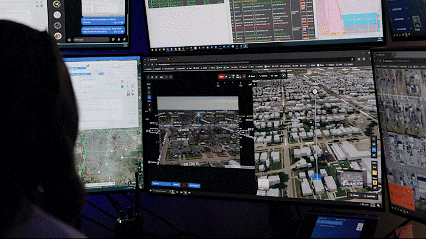
Share a common operating picture.
When everyone sees the same live view, coordination improves, decisions are smarter and response is safer.
Stream live video instantly using ReadyLink and share the feed through SMS alerts, email groups, or shared links.
Give dispatch, patrol, and command the same real-time view on any device.
Integrate with Axon Respond, Fusus, and other platforms to get video in front of the right people at the right time in your Real Time Control Center (RTCC).

Fly anytime, anywhere.
Emergencies don’t wait for good weather or daylight. Your DFR program shouldn’t either. Skydio drones are built to fly when and where you need them, delivering continuous coverage 24/7.
Fly through rain, wind, snow, daylight, or zero-light conditions with advanced obstacle avoidance and autonomy.
Fly wherever you need to with connectivity that goes the distance. Use multiple network connections for the best performance.

Lead with autonomy.
Faster response starts with autonomous control. Skydio Autonomy handles the complexity of flight, allowing operators to focus on the mission, not the controls.
Command multiple drones at once—launch, control, and reassign across your fleet with DFR Command. Automatic deconfliction keeps multiple drones flying safely together.
Fly to any point automatically—Skydio Pathfinder charts and executes safe, optimized routes automatically.
Track and follow people or vehicles, keeping subjects in frame with Skydio Shadow.

Operate remotely.
DFR Command is the central operating system for remote flight operations. Run missions, manage docks, and coordinate teams across jurisdictions—without limits.
Oversee multiple docks, aircraft, and live missions from a single map view.
Switch control seamlessly between remote and local operators for continuous response.
Coordinate operations across shifts, regions, and agencies through one connected platform integrated with your RTCC.
See every detail.
Clear visuals drive confident decisions. Skydio drones give teams the clarity they need—inside buildings or across city blocks, in daylight or darkness.
Capture high-resolution, evidentiary video with X10 and R10 sensors.
Use high-resolution zoom to identify details, such as a license plate or subject movement, from a safe distance.
Use advanced thermal imaging on X10 to locate people or heat signatures through smoke, foliage, or darkness.

Secure and upload evidence.
Evidence must stand up to scrutiny—from the field to the courtroom. Skydio meets the FBI’s CJIS Security Policy v6.0 (G6) requirements, ensuring evidence data is encrypted, access-controlled, and auditable.
Automatically upload video, photos, and telemetry to evidence systems such as Axon Evidence.
Maintain chain of custody with embedded watermarks that log date, time, aircraft, and sensor data.
Verify authenticity through cryptographic file hashes that maintain evidentiary integrity.

Build trust through transparency.
Community trust starts with visibility. DFR Command includes a Transparency Dashboard that lets agencies share flight activity openly with their communities while protecting operational details.
Publish mission history, locations, and summaries through configurable transparency dashboards.
Share data that demonstrates accountability without compromising safety or privacy.
Strengthen public confidence through proactive communication and accessible reporting.

Maintain one objective record.
Every incident deserves a single source of truth. Skydio drones capture verifiable, time-stamped data—ensuring what’s seen and stored reflects exactly what happened.
Synchronize drone, body-worn, and in-car footage using embedded timestamps and metadata.
Include date, time, aircraft, and sensor details in every file for traceable context.
Protect evidentiary integrity with cryptographic validation and immutable records.

The nation’s top agencies fly Skydio. Build your DFR program with an expert today.


THIS PRODUCT OR SERVICE HAS NOT BEEN APPROVED OR ENDORSED BY ANY GOVERNMENTAL AGENCY, AND THIS OFFER IS NOT BEING MADE BY AN AGENCY OF THE GOVERNMENT.